Tuesday, January 18, 2011

Saw this today in Edinburgh :


close up :


Doesn't do a lot for the reputation of Scotland's eating habits ...

Wednesday, January 12, 2011

A beautiful satellite photo of one of my favourite countries in the world : the Maldives.


"On a relatively clear day, the atolls and islands of the Maldives glow like a necklace of speckled jade beads floating on the deep blue waters of the northern Indian Ocean. The Maldives are an island nation made up of a chain of 1,192 small coral islands grouped into 26 clusters of atolls. It has a population of about 330,000. The capital and largest city is Male, with a population of about 80,000. The coral archipelago stretches in a north-south chain for almost 560 miles south-west of India, and sits upon a vast undersea mountain range. Arguably the lowest-lying country in the world, the average elevation is just 1m above sea level". The Guardian Satellite Eye. (links are mine)

Tuesday, January 4, 2011

Piton de la Fournaise's most recent eruption ended last month. The Fournaise is one of the world's most active volcanoes and below is a list of its recent eruptions (since 1998). 

Français : Contact entre la lave et l'océan. U...
Piton de la fournaise eruption, lava reaches sea 26 Feb 2005 (Photo credit: Wikipedia)

Before the eruption in 1998 which lasted six months there hadn't been one since 1992. Altogether there have been 300 recorded eruptions since the island was inhabited in the mid-17th century (and probably a few more that went unrecorded in my opinion).

Start Date: 2010 October 14 - Stop Date: 2010 December 10

Start Date: 2009 November 5 - Stop Date: 2010 January 12

Start Date: 2008 September 21 - Stop Date: 2009 February 4

Start Date: 2006 July 20 - Stop Date: 2007 May 1

Start Date: 2005 October 4 - Stop Date: 2006 January 18

Start Date: 2005 February 17 - Stop Date: 2005 February 26

Start Date: 2004 May 2 - Stop Date: 2004 October 16

Start Date: 2003 May 30 - Stop Date: 2004 January 10

Start Date: 2002 November 16 - Stop Date: 2002 December 3

Start Date: 2002 January 5 - Stop Date: 2002 January 16

Start Date: 2001 June 11 - Stop Date: 2001 July 7

Start Date: 2001 March 27 - Stop Date: 2001 April 4

Start Date: 2000 June 23 - Stop Date: 2000 November 13

Start Date: 2000 February 14 - Stop Date: 2000 March 4

Start Date: 1999 July 19 - Stop Date: 1999 October 23

Start Date: 1998 March 9 - Stop Date: 1998 September 20 (?)

English: Eruption of Piton de la Fournaise, la...
Eruption of Piton de la Fournaise (Photo credit: Wikipedia)

Source : Global Volcanism Program, Smithsonian Institution which lists all known eruptions for the Fournaise.

See also Reunion Island Geological Information Center for up-to-the minute volcano information in English and live webcams.

Français : Eruption du Piton de la Fournaise (...
Piton de la Fournaise Eruption (Aug 2004) (Photo credit: Wikipedia)

Follow this link for my photos of the January 2002 eruption.

English: Eruption of Piton de la Fournaise, la...
Eruption of Piton de la Fournaise (Photo credit: Wikipedia)


Saturday, January 1, 2011

The last two days of 2010 saw us visiting Brussels. I flew over to Belgium for a short trip from Scotland where I was spending a month with my family. Although I've been to Belgium a few times before (Bruges, Tournai) this was the first time I'd been to the country's capital.


We started our sight-seeing with the Royal Palace which was built on the site of the former Palace of the Dukes of Brabant, destroyed by fire in 1731. Building started in 1820 under the reign of King William, later it was modified in 1904 under Leopold II, who had it rebuilt in Louis XVI style. The side wings date from the 18th century and at the end of each wing is a pavilion. It isn't actually used as a royal residence however, as the king and his family live in the Royal Castle of Laeken on the outskirts of Brussels.


Royal Palace of Brussels

In the nearby Montagne de la Cour street (Coudenberg) is the lovely Art Deco Old England building, designed by Paul Saintenoy in 1899 using glass and girded steel. Formerly a department store, since 2000 it has housed the restaurant of the Musical Instruments Museum (MIM).


Old England building, Montagne de la Cour street

In the same street Paul Saintenoy also designed this corner house (see below) in 1895, mixing renaissance and gothic styles, and incorporating a sundial. It was – and still is – a pharmacy, first occupied by Charles Delacre, who believed that chocolate was the best curative. He sold so much of his chocolate that he soon opened a separate chocolate shop next door. Finally he relocated his factory to larger premises, but the pharmacy remained.


Delacre Pharmacy in Montagne de la Cour street

Nearby is the Mont des Arts (Kunstberg) a geometric garden which was designed by landscape architect René Péchère. From here you can get some of the best views of Brussels.

Mont des Arts, with spire of Brussels City Hall in the background

A short walk away is the Parc du Cinquantenaire (Jubelpark). Most of the buildings which surround the park in a U-shape were commissioned by the Belgian government under the patronage of King Leopold II for the 1880 National Exhibition commemorating the fiftieth anniversary of Belgian independence.

interesting clock, near Parc du Cinquantenaire (note the bell on top)

Next we headed to Brussels' famous Grand Place (Grote Markt), passing some interesting shopfronts along the way.


The Grand Place is known as one of Europe's most beautiful city squares, and has been classed as UNESCO World Heritage since 1998.

partial view of Brussels City Hall


The Maison des Ducs de Brabant (Hertogen van Brabant)
is actually one facade covering seven guildhouses

The earliest written reference to the square dates from 1174. 

some of the other guildhalls on Grand Place

Belgium's first Protestant martyrs, Hendrik Voes and Jan Van Essen, were burned by the Inquisition here in 1523.

 Brussels City Museum, located in the
Maison du Roi (Broodhuis) building

In August 1695 during the War of the League of Augsbourg, most of the houses on the Grand-Place were destroyed during a bombardment of flaming canon balls by French troops.  Only the facade and the tower of the City Hall, which were the target, and some stone walls resisted. The houses surrounding the square were quickly reconstructed, in stone this time, by the various guilds. These are the buildings which are still standing today.


a life-sized nativity creche in Grand Place

Next we visited Manneken Pis, which means 'Little Man Pee' in Marols, a Dutch dialect spoken in Brussels. One of Brussels' most famous landmarks, there are many stories about the statue's meaning. It is believed to have been inspired by a child who, while in a tree, found a special way to drive away invading troops. Another story goes that a father was missing his child and made a declaration to the city that when he found him he would build a statue of him, doing whatever it was that he was doing. It has also been said a witch turned him to stone for peeing on her property. None is definitively true. The original statue was erected in 1388, and the current statue in 1618 or 1619.

Manneken Pis, a small bronze fountain
sculpture only 61 cm high

a festive shopfront near Manneken Pis

Belgium is of course famous for its comic strips. Just a few steps away from Manneken Pis, in Rue de l’Étuve (Stoofstraat) a monumental fresco depicts Tintin, Snowy and Captain Haddock in The Calculus Affair.

Tintin-themed fresco, Rue de l'Etuve

decorative tiles on a building

interesting building

In the Sablon district of Brussels is Petit Sablon Square. In the middle of the square is a fountain with a statue of Counts Egmont and Horne, who were symbols of resistance to Spanish tyranny in the 16th century.

    Counts Egmont & Horne statue, Petit Sablon Square

    The square is surrounded by Gothic columns with bronze statues on top. They represent 48 traditional trades (goldsmiths, weavers, tailors, etc).


    Statue representing saddlers & coach builders (holding
     a carriage shaft and with a saddle on shoulder)

    At N° 9 Petit Sablon Square this early 17th century building with crow-stepped gables was formerly an inn called Au Roy d'Espagne:

    Au Roy d'Espagne former inn

    Also bordering the square is Our Lady of Sablon, a late Gothic church dating from around 1400 to about 1594. It was paid for by the city's Guild of Crossbowmen, who called it optimistically Notre-Dame des Victoires (Our Lady of Victories), and it was their guild church.

    Notre Dame du Sablon church (note three trade statues in front)

    Our final visit was to the Atomium, which was originally built for the 1958 World's Fair, and designed by the engineer André Waterkeyn.

    The Atomium, an iconic Brussels structure

    It has nine stainless steel spheres and stands 102 metres tall. It forms the shape of a unit cell of an iron crystal magnified 165 billion times.
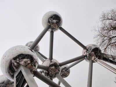
    looking at the Atomium from underneath


    Useful links:


    Suggested reading:

    my father-in-law's vintage Michelin guide 

    Thursday, December 23, 2010

    This is a great gift for those that enjoying  travelling, or just enjoy thinking about travelling. Every day shows a different destination (one page for Saturday/Sunday). 1,000 Places to See Before You Die Page-A-Day Calendar 2011

    Friday, December 3, 2010

    This handy little online tool helps you calculate the time anywhere in the world. It takes into account daylight saving time, local time zone and accepts dates in the past or future.

    Saturday, November 13, 2010


    For our second trip to Thailand we flew directly to Phuket from Seoul. As this was to be a diving trip, we then headed about an hour up the coast to Khao Lak, in Phang Nga Province.  We were staying for a week, and we'd be taking a 3-day liveaboard to the Similan Islands with Wicked Diving.

    our accommodation in Khao Lak

    However the weather decided differently. Normally the rainy season is finished by late October, and this was early November. However a bad weather system blew in, and our liveaboard had to be cancelled. You can see from the photos that the weather was quite cloudy (when it wasn't rainy).

    fishing boat coming back to port because of the storm

    We actually got to embark on our liveaboard, but as the authorities had closed the Similan Islands and the fishing boats were coming back to port because the weather was so bad it was decided to cancel our trip for obvious reasons. 

    fishing boats, Khao Lak port


    beach, Khao Lak

    So we visited the surrounding area, including a waterfall near Khao Lak where I got bitten by leeches for the first (and hopefully last?) time in my life!

    waterfall, near Khao Lak


    We also visited a rubber plantation. Rubber is harvested mainly in the form of latex.

    a plantation of rubber trees

    The sticky, milky latex is drawn off by making incisions into the bark and collecting the fluid in vessels. This process is called "tapping". The latex then is refined into rubber ready for commercial processing.

    collecting the latex from a rubber tree

    When the 2004 tsunami struck South Asia, the Khao Lak region was the hardest-hit area in Thailand with over 4,000 deaths, more than 3,000 who were never accounted for, and thousands who were injured. It has since made an impressive recovery and is once again a popular tourist destination.

    shrine

    this little fellow looks like he's wearing a bow tie!

    To compensate for not diving the Similan Islands, Wicked Diving suggested going to  Chiaw Lan Lake in Khao Sok National Park for two days diving.

    'Unique diving in a jungle paradise' - Khao Lak (source)

    This was only the second time I'd dived in fresh water - the first time was in Lake Baikal in Siberia.

    source

    At 739 km2, Khao Sok NP is Thailand's largest protected area. It comprises the largest area of virgin forest in Southern Thailand and is a remnant of rainforest which is older and more diverse than the Amazon Rainforest.

    limestone cliffs at Khao Sok

    The park is famous for having the enormous Rafflesia flower, but unfortunately none were flowering while we were there.

    limestone cliffs, Khao Sok

    Chiaw Lan is in fact an enormous man-made reservoir and diving there is a very eerie experience - visibility is low (you need a torch even in broad daylight) and you can suddenly find yourself face to face with submerged tree branches with little warning.


    decorations on long-tail boats

    Our transport across and round the lake was by long-tail boat, which gets its name from the trailing drive shaft and propeller at the back. The garlands and scarves that decorate the bow are there to provide good luck and protection - we had to be careful not to step on them or it would offend the spirits.

    decorations on long-tail boats

    We did three dives (at Peter Pan Cave, Catfish Cave and another spot with no name), at an average depth of 12-13 metres, although the lake is at least 60 metres deep. Wildlife underwater was fairly limited - we mainly saw catfish.


    Our accommodation was at a floating village on the lake, from where we could hear gibbons.


    The final day of our trip was spent exploring Phuket before our late evening flight. Phuket is Thailand's largest island, and is connected to the mainland by road bridges. Some of the resorts have the reputation as party centres - a very different atmosphere from the quieter Khao Lak.

    temple, Phuket

    We finished the day with cocktails at the Evason Phuket, which I was curious to visit as I've stayed in two of their sister resorts (Soneva Fushi and Soneva Gili) in the Maldives.

    sunset at the infinity pool, Evason Phuket


    If you enjoyed this post you might also like: